By Victoria Lee
With three months of summer break from university, why not lay down some foundations for a cutting-edge, globally significant project?
An exciting ecological initiative is coming to life at the University of St Andrews.
The St Andrews Forest programme is a global network of nature-based projects primarily intended to offset the carbon footprint of student travel to and from the University of St Andrews, with additional benefits to both ecological and human communities. Launched in 2021, it currently comprises of areas of planted trees across southeast Scotland, but there are plans underway to expand the forest locations across the globe in the near future. Through private partnerships and the support of students, staff, and members of the public, forest sites can be established anywhere in the world and become part of the St Andrews Forest.
With concrete goals and a focus on community planning, the St Andrews Forest is shaping up to be a great climate action initiative. But one vital next step in its development is identifying specific data that need to be collected from forest locations in order to quantify progress towards its goals of carbon sequestration, supporting biodiversity, and ecosystem services (which was defined as the impact of the environment on people’s daily lives and wellbeing).
That is where we STEPped in!
Through the University’s 2022 Summer Teams Enterprise Programme (STEP), a team of seven St Andrews undergraduate students from across degree programmes and with diverse backgrounds were brought together to create a draft protocol for assessing the benefits of the Forest programme. With team members located in Scotland, the US, and Peru, we received our assignment from STEP supervisors Dr Lydia Cole, Dr Richard Streeter, and St Andrews Forest Programme Manager, David Toy. We had six weeks to create a protocol for assessing and monitoring carbon sequestration, biodiversity, and ecosystem services. We formed three groups, with each specialising in one of these indicators, and got to work.
As our research began, we soon realized that there was scope for each group to spend years exploring the nuances of their chosen indicators – but we only had six weeks. As such, we would have to make choices about which components of carbon sequestration, biodiversity, and ecosystem services we should measure to demonstrate the ecological and societal benefits of the Forest programme.
For the carbon group, it was simple to identify the key component that would indicate the carbon value of the St Andrews Forest: levels of carbon sequestration in trees above ground. Next, we had to decide on the best methodology for carbon measurement, taking into account labour efficiency, cost-effectiveness, and the impacts of the chosen methodology on the environment itself. Some methods we considered – including manual measurement, satellite imaging, and direct estimation through burning trees – did not meet these criteria. Manual measurement would require a vast amount of people on the ground, satellites were expensive, and burning trees would be counterproductive and extremely destructive. But with support from graduate mentor Georg Kodl, the carbon group identified remote sensing, using unmanned aerial vehicles (UAVs), or drones, as their main method for monitoring carbon levels (see Fig. 1). Remote sensing via UAVs is an effective approach to producing high resolution images of forested areas and measuring carbon stores. The UAVs’ cameras create aerial measurements of selected forest areas, as well as individual tree sizes. These are then synthesized into indicators of tree density and biomass, which are used to calculate carbon storage.

While the carbon group was able to dedicate most of their time to researching methodology, the biodiversity and the ecosystem services groups had to invest more time in exploring which components of the Forest would be most useful to measure. This led to weeks of discussion and research into potential areas of focus that took us into the core tenets of the topics themselves. We discovered that biodiversity not only centres living things, but also encompasses the interplay between species and their environments. Ecosystem services, an often overlooked indicator in scientific analysis, is important for grounding ecological initiatives in political and cultural contexts – and particularly interesting to our team members with backgrounds in IR and Anthropology.
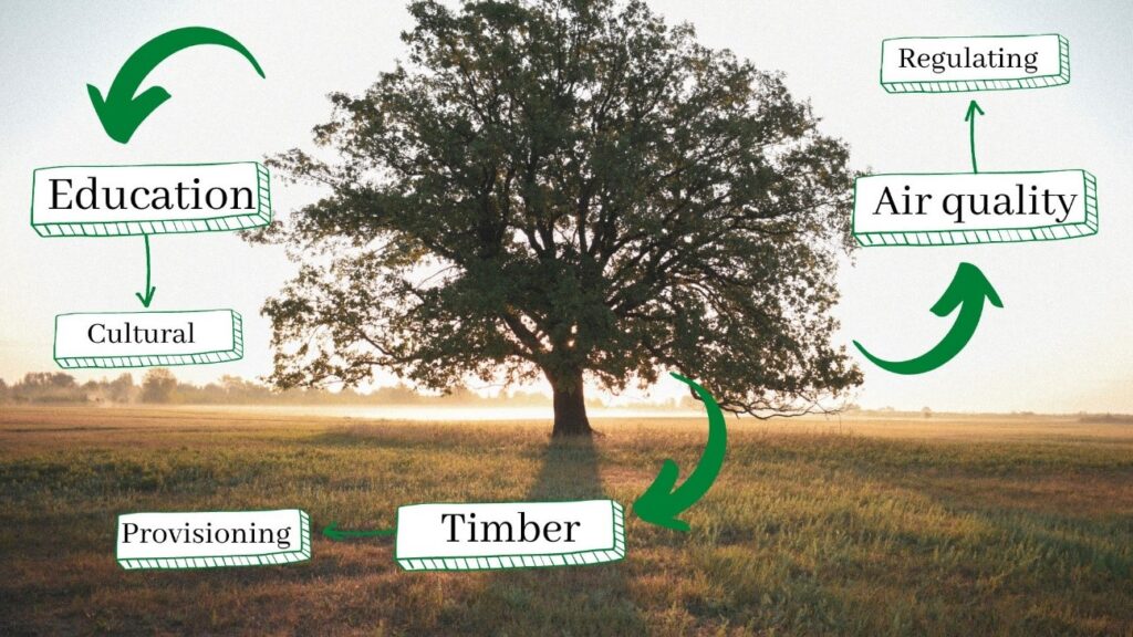
The range of biodiversity variables and ecosystem services that we could measure in theory was much greater than the number we could assess in the time available. So eventually, with the guidance of graduate mentor Abi Whitefield, the biodiversity and ecosystem services groups decided to take a ‘prioritization’ approach. Each group focused on a set of key variables that were commonly measured in forest ecosystems, were feasible to measure, and were considered to be of central importance to Forest programme stakeholders. The biodiversity team prioritized a set of indicator species to measure, such as bats and ground beetles, as well as structural forest indicators, such as shrub layer cover, tree species diversity, and the abundance of deadwood. The ecosystem services team used indicators from the Millennium Ecosystem Assessment (regulating, provisioning, supporting, and cultural services) to measure the types of services the forest ecosystem offered (Fig. 2).

Once each group had finally overcome the hurdle of identifying what would be assessed and how, our next step was navigating connections and overlaps between the three groups. For example, remote sensing was an overlapping method considered by both the biodiversity and carbon groups for collecting data. Similarly, we realized that enhancing biodiversity overlapped with ecosystem services (Fig. 3). Discussions on how to integrate the work of each group into a cohesive monitoring protocol for the Forest led to some collaboration and cross-referencing in the final report.

Navigating these nuances ultimately led us to realise a fourth, crucial dimension of our protocol: site-specificity. Each St Andrews Forest site will require different priorities with regard to setting, managing, and monitoring carbon, biodiversity, and ecosystem services. For example, a potential Forest site in Uruguay that aims to restore 20,000 hectares of degraded grazing land will have very different priorities than the Clackmannanshire site in terms of geography, community needs, and monitoring time. As such, criteria for ‘success’ across various sites will differ, even when applying the same protocol. We discussed over the course of the project whether we should attempt to reconcile these differences, or allow Forest sites to ‘pick and choose’ relevant aspects of the protocol. But while recognizing the significance of each of the protocol’s three dimensions, we ultimately chose to prioritize flexibility, to align with the global structure of the St Andrews Forest.
The protocol we developed will form the basis for data collection at St Andrews Forest sites around the world, and allow the environmental and social contributions of the Forest to be quantified and clearly communicated. We additionally hope that the process of creating the protocol can serve as a model for future forms of student-led climate action. As a global team of young people all motivated by the urgent need to address climate change, we were able to utilize our diverse perspectives and experiences to contribute to this impactful ecological project.
While we were happy with the outcome of our project, we all appreciated that the hard task of actually measuring and monitoring the carbon, biodiversity, and ecosystem services of the St Andrews Forest programme was yet to begin. Turning protocol into practice will be the next step for a longer-term project, and will involve answering important questions such as: how will the protocol be applied and adapted at field sites across the globe? And, what will be the carbon footprint of this monitoring and data collection? But that sense of incompletion, of being at the start of a big endeavour, is exciting – it means that there is so much more to learn and gain from this project. We are all so fortunate to have had the opportunity to grow alongside the Forest, and now to watch where our paths continue to intertwine.

To read the full draft protocol and its associated literature reviews, email Lydia Cole (lesc1@), the lead supervisor of the STEP project. For more information on the St Andrews Forest initiative, you can sign up to the newsletter here.
Sources
Carreras Avila, P., Eastwood, O., Hardin, A., Hummelsberger, A., Lee, V., Li, C., and Tam, T. (2022) “A Protocol for Assessing the Carbon, Biodiversity, and Environmental Benefits of the St Andrews Forest.”
Ecologi (2022) Forest plantation on degraded grassland in Uruguay. Available at: https://ecologi.com/projects/forest-plantation-on-degraded-grassland-in-uruguay
University of St Andrews (2022) The St Andrews Forest. Available at: https://forest.st-andrews.ac.uk/.


